Picture 1 of 3


Gallery
Picture 1 of 3


Have one to sell?
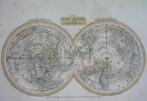
1835 ORIGINAL MAP WORLD POLAR PROJECTION UNITED STATES TEXAS AUSTRALIA EUROPE
US $49.99
ApproximatelyRM 211.38
or Best Offer
Condition:
“SOME STAINS, SOME SCATTERED SPOTTING AND FOXING //// I INVITE YOU TO MY SHOP //////”
Oops! Looks like we're having trouble connecting to our server.
Refresh your browser window to try again.
Shipping:
US $16.00 (approx RM 67.66) Economy Shipping from outside US.
Located in: Zary, Poland
Delivery:
Estimated between Mon, 11 Aug and Mon, 25 Aug to 94104
Returns:
No returns accepted.
Coverage:
Read item description or contact seller for details. See all detailsSee all details on coverage
(Not eligible for eBay purchase protection programmes)
Shop with confidence
Seller assumes all responsibility for this listing.
eBay item number:205590712864
Item specifics
- Seller Notes
- “SOME STAINS, SOME SCATTERED SPOTTING AND FOXING //// I INVITE YOU TO MY SHOP //////”
- Printing Technique
- Copper Plate
- US State
- AK, HI, AL, FL, GA, MS, NC, SC, AR, IA, KS, LA, MO, NE, AZ, CA, CO, NM, NV, UT, Alabama, Alaska, Arizona, Arkansas, California, Colorado, Connecticut, Florida, Georgia, Illinois, Indiana, Iowa, Louisiana, Massachusetts, Michigan, Mississippi, New Mexico, New York, Oklahoma, Oregon, Pennsylvania, South Carolina, Texas, Virginia, Washington, West Virginia
- Cartographer/Publisher
- Meyer
- City
- Boston Havana Montreal Quito Buenos Aires Mexico City Santiago
- Date Range
- 1700-1799
- Continent
- North America / South America
- Type
- Political Map
- Mexican State
- Aguascalientes, Baja California, Baja California Sur, Campeche, Chiapas, Chihuahua, Coahuila, Colima, Durango, Guanajuato, Guerrero, Hidalgo, Jalisco, Michoacán, Morelos, Nuevo León, Oaxaca, Puebla, Querétaro, Quintana Roo, San Luis Potosí, Sinaloa, Sonora, Tabasco, Tamaulipas, Tlaxcala, Veracruz, Yucatán, Zacatecas
- Format
- Atlas Map
- Canadian Province
- Alberta, British Columbia, Manitoba, New Brunswick, Newfoundland & Labrador, Northwest Territories, Nova Scotia, Nunavut, Ontario, Prince Edward Island, Quebec, Saskatchewan, Yukon
- Year
- 1835
- Original/Reproduction
- Antique Original
- Country/Region
- United States
Item description from the seller
Seller feedback (1,158)
- u***z (677)- Feedback left by buyer.Past monthVerified purchaseShipping - reasonable. Packaging - professionally packed. Item - as described. Value - value for money. KInd seller. Knows his stuff well.
- i***l (916)- Feedback left by buyer.Past monthVerified purchaseGreat transaction! Buyer was very prompt and professional. Shipping did take a few weeks, but that is completely normal for a package from Poland, and was clear before I purchased it. The item arrived in great condition, and will be the centerpiece of my map collection. Bid and/or buy with confidence! A+++ experience.
- v***i (295)- Feedback left by buyer.Past monthVerified purchaseExcellent international transaction. A+++ Thanks!
More to explore :
- United States of America Texas Antique Original Antique North American Maps & Atlases,
- United Kingdom Antique Original Antique Europe Maps & Atlases,
- United Kingdom Antique Original Antique Europe Sheet Maps,
- North Polar Region Antique Original Antique World Maps & Atlases,
- Vintage Original Europe School Maps,
- United States of America Texas Antique North America Wall Maps,
- London United Kingdom Antique Original Antique Europe Maps & Atlases,
- Antique Original Antique Europe Maps & Atlases,
- South Australia Antique Original Antique Australia/Oceania Atlas Maps,
- Melbourne Australia Antique Original Antique Australia/Oceania Maps & Atlases