Picture 1 of 8


Gallery
Picture 1 of 8


Have one to sell?
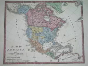
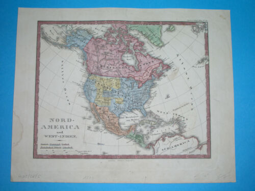
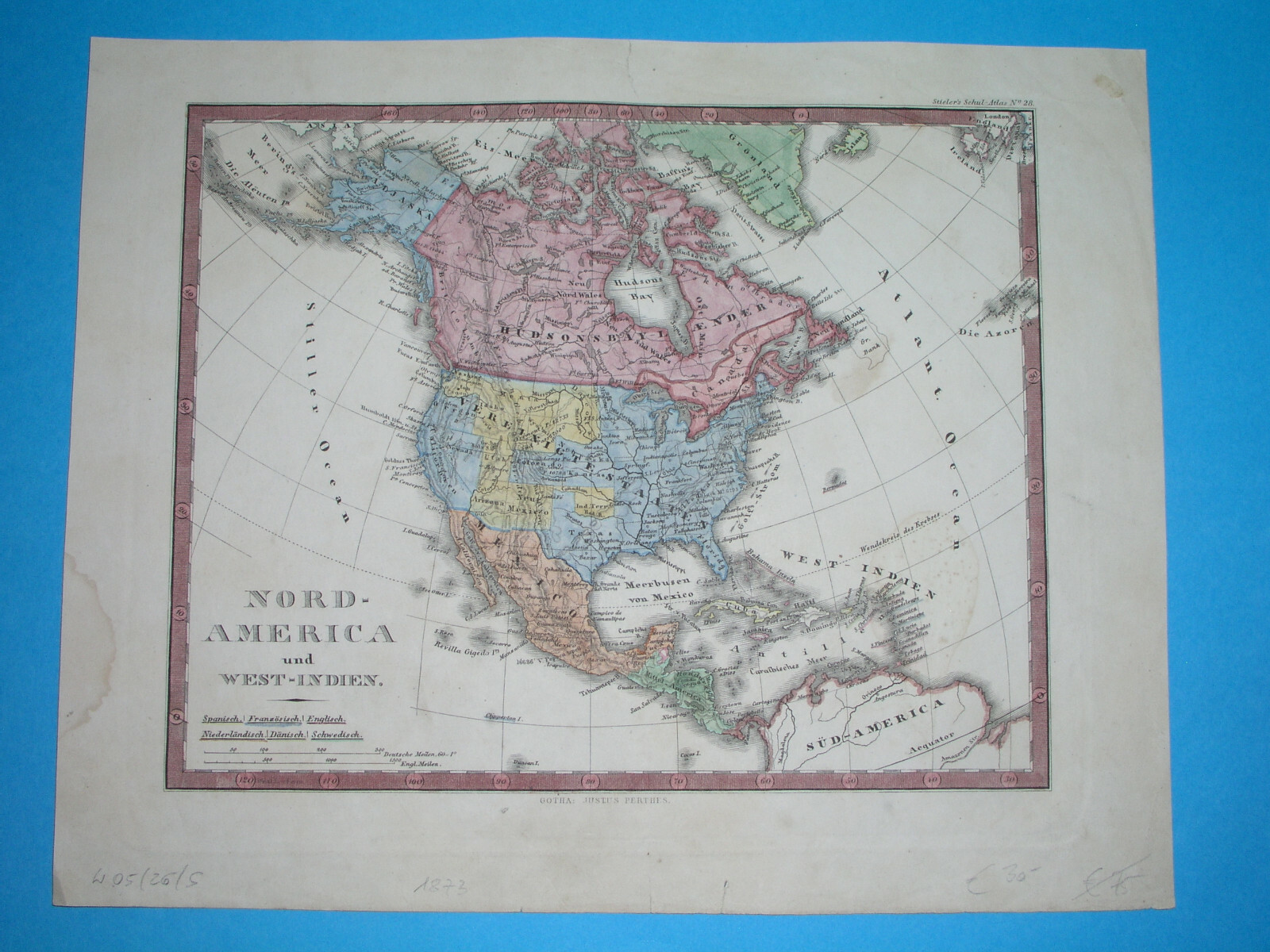
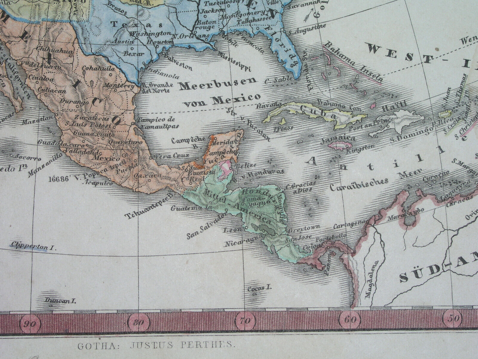
1873 ORIGINAL MAP TEXAS UNITED STATES CALIFORNIA IOWA FLORIDA CUBA MEXICO CANADA
US $44.99
ApproximatelyRM 190.17
or Best Offer
Condition:
“SOME STAINS, SOME SCATTERED SPOTTING AND FOXING //// I INVITE YOU TO MY SHOP”
Oops! Looks like we're having trouble connecting to our server.
Refresh your browser window to try again.
Returns:
No returns accepted.
Coverage:
Read item description or contact seller for details. See all detailsSee all details on coverage
(Not eligible for eBay purchase protection programmes)
Shop with confidence
Seller assumes all responsibility for this listing.
eBay item number:205590702579
Item specifics
- Seller Notes
- “SOME STAINS, SOME SCATTERED SPOTTING AND FOXING //// I INVITE YOU TO MY SHOP”
- Date Range
- 1700-1799
- Type
- Political Map
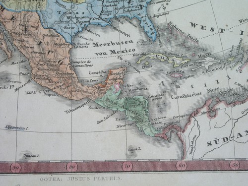
- Mexican State
- Aguascalientes, Baja California, Baja California Sur, Campeche, Chiapas, Chihuahua, Coahuila, Colima, Durango, Guanajuato, Guerrero, Hidalgo, Jalisco, Michoacán, Morelos, Nayarit, Nuevo León, Oaxaca, Puebla, Querétaro, Quintana Roo, San Luis Potosí, Sinaloa, Sonora, Tabasco, Tamaulipas, Tlaxcala, Veracruz, Yucatán, Zacatecas
- Printing Technique
- Copper Plate
- Format
- Atlas Map
- US State
- AK, HI, AL, FL, GA, MS, NC, SC, Alabama, Alaska, AR, IA, KS, LA, MO, NE, Arizona, Arkansas, AZ, CA, CO, NM, NV, UT, California, Colorado, CT, MA, ME, NH, RI, VT, DC, DE, MD, NJ, NY, PA, Florida, Georgia, Illinois, Indiana, Maryland, Massachusetts, Michigan, Minnesota, Missouri, Nebraska, New York, Ohio, Oregon, Pennsylvania, Texas, Utah, Virginia, Washington
- Canadian Province
- Alberta, British Columbia, Manitoba, New Brunswick, Newfoundland & Labrador, Northwest Territories, Nova Scotia, Nunavut, Ontario, Prince Edward Island, Quebec, Saskatchewan, Yukon
- Year
- 1873
- Cartographer/Publisher
- Stieler / Stulpnagel / Perthes
- Original/Reproduction
- Antique Original
- City
- Washington Houston Dallas San Francisco Chicago Boston Miami
- Country/Region
- NORTH AMERICA / WEST INDIES / GUATEMALA
Item description from the seller
Seller feedback (1,163)
- e***h (11)- Feedback left by buyer.Past monthVerified purchaseExceptional map! Extremely polite and excellent experience. Item as described, with very strong packaging and extremely fast shipping. Shipping cost was reasonable and worth it for the speed. Thank you!”
- e***h (11)- Feedback left by buyer.Past monthVerified purchaseExtremely polite and excellent experience. Item as described, with very strong packaging and extremely fast shipping. Shipping cost was reasonable and worth it for the speed. Thank you!”
- e***h (11)- Feedback left by buyer.Past monthVerified purchaseExceptional map, wonderful condition. Extremely polite and excellent experience. Item as described, with very strong packaging and extremely fast shipping. Shipping cost was reasonable and worth it for the speed. Thank you!”
More to explore :
- Mexico Texas Antique Original Antique North American Maps & Atlases,
- Mexico California Antique Original Antique North American Maps & Atlases,
- United States of America Texas Antique Original Antique North American Maps & Atlases,
- United States of America California Vintage Original Antique North American Maps & Atlases,
- United States of America Iowa Antique North America Railroad Maps,
- United States of America Iowa Antique North America County Maps,
- United States of America Texas Antique North America Railroad Maps,
- United States of America Texas Antique North America Folding Maps,
- United States of America California Antique North America County Maps,
- United States of America California Antique North America Nautical Maps