Picture 1 of 5


Gallery
Picture 1 of 5


Have one to sell?
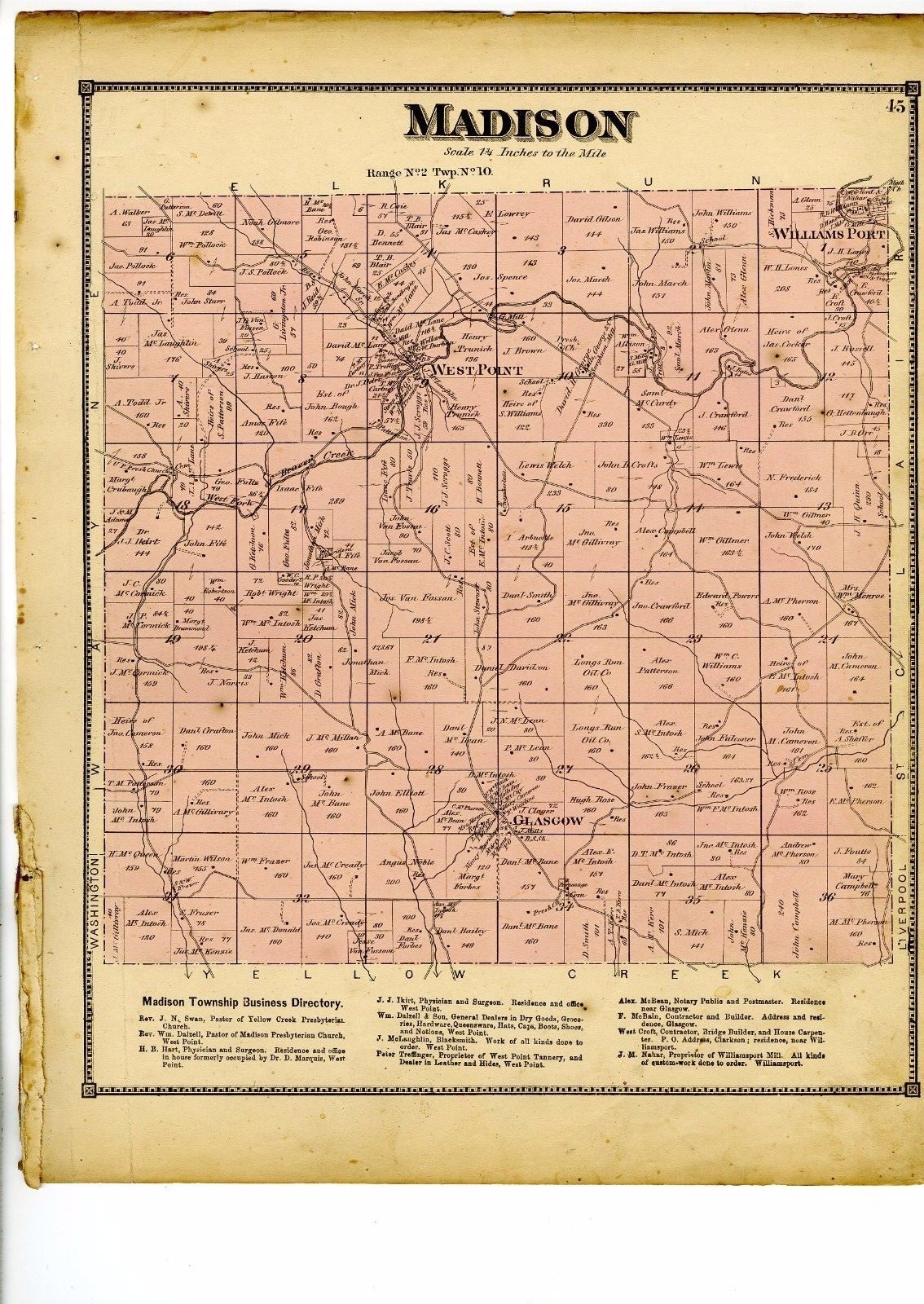
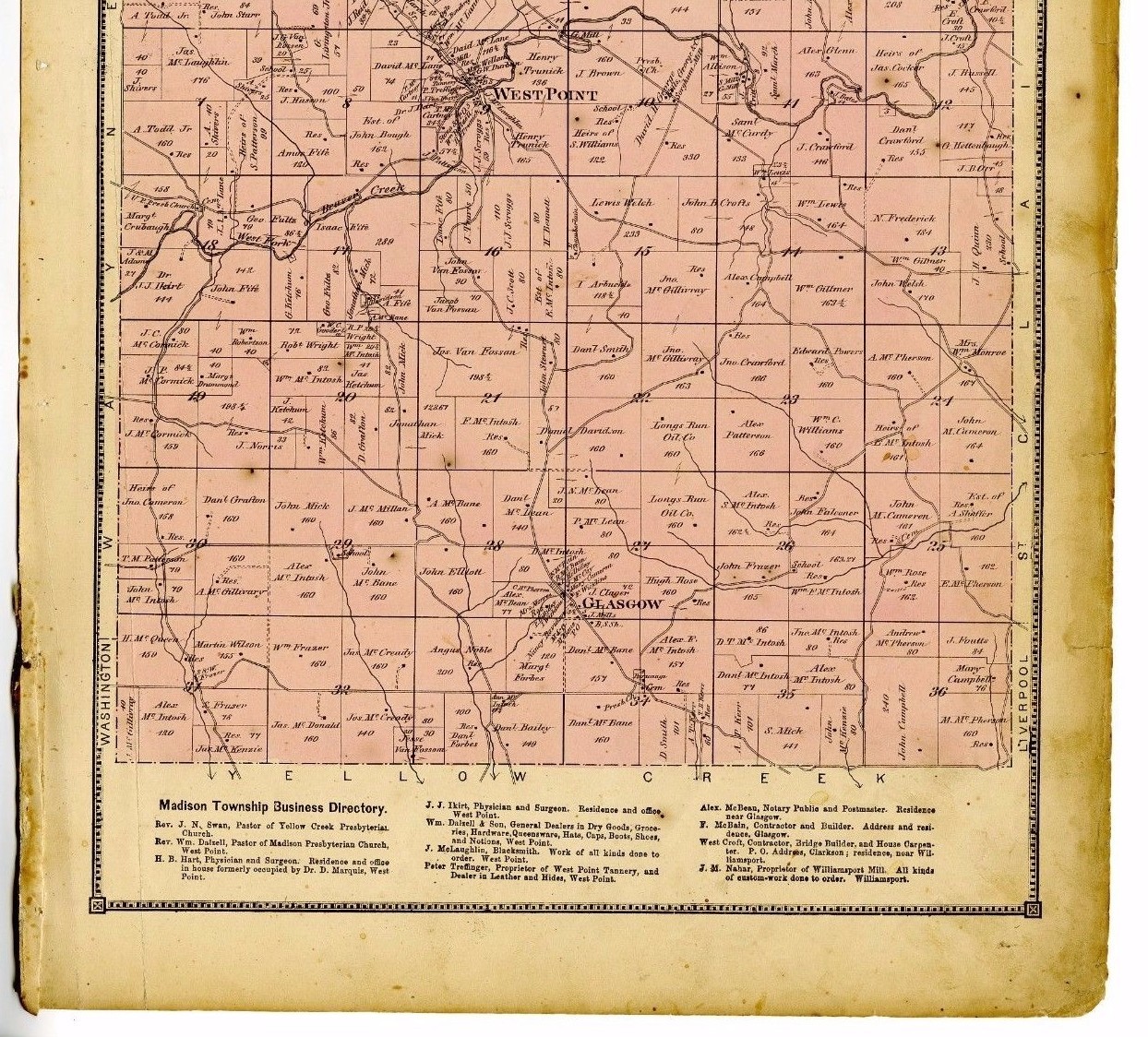
Rare 1870 Map of Madison, Ohio, with family names, from Columbiana County atlas

US $32.00
ApproximatelyRM 136.90
or Best Offer
Condition:
Oops! Looks like we're having trouble connecting to our server.
Refresh your browser window to try again.
Shipping:
US $10.85 (approx RM 46.42) USPS First Class®.
Located in: Athol, Massachusetts, United States
Delivery:
Estimated between Thu, 7 Aug and Wed, 13 Aug
Returns:
14 days return. Buyer pays for return shipping. If you use an eBay shipping label, it will be deducted from your refund amount.
Coverage:
Read item description or contact seller for details. See all detailsSee all details on coverage
(Not eligible for eBay purchase protection programmes)
Seller assumes all responsibility for this listing.
eBay item number:201989328802
Item specifics
- Continent
- North America
- North America States & Provinces
- Indiana
- Original/Reproduction
- Original
- Type
- City Map
- Year
- 1870
- US State
- IL, IN, MI, OH, WI, Ohio
- Maker
- D J Lake / C O Titus
Item description from the seller

Popular categories from this store
Seller feedback (438)
- g***9 (1352)- Feedback left by buyer.Past 6 monthsVerified purchaseLovely map and so happy with its excellent condition! Thank you!
- 6***t (2412)- Feedback left by buyer.More than a year agoVerified purchaseExcellent service. Highly recommend!!!!!!!!!!!!!1877 map of Topsham, Vermont from Atlas of Orange County, with family names (#193013837804)
- u***t (2252)- Feedback left by buyer.More than a year agoVerified purchaseGreat Seller.Massachusetts Milk Bottle South Hadley (#204552929758)
More to explore :
- Ohio County Map Antique North America Atlas Maps,
- Ohio County Map Antique North America Atlas,
- County Map Antique Atlas Maps,
- County Map Antique Atlas,
- Contemporary County Map Antique Atlas Maps,
- County Map Antique Asia Atlas Maps,
- Ireland County Map Antique Europe Atlas Maps,
- Greece County Map Antique Europe Atlas Maps,
- Copper Plate County Map Antique Atlas Maps,
- Delaware County Map Antique North America Atlas Maps
Popular categories from this store
Seller feedback (438)
- g***9 (1352)- Feedback left by buyer.Past 6 monthsVerified purchaseLovely map and so happy with its excellent condition! Thank you!
- 6***t (2412)- Feedback left by buyer.More than a year agoVerified purchaseExcellent service. Highly recommend!!!!!!!!!!!!!1877 map of Topsham, Vermont from Atlas of Orange County, with family names (#193013837804)
- u***t (2252)- Feedback left by buyer.More than a year agoVerified purchaseGreat Seller.Massachusetts Milk Bottle South Hadley (#204552929758)