Picture 1 of 6


Gallery
Picture 1 of 6


Have one to sell?
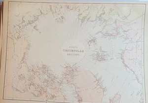
1882 Blackie large map North Circumpolar Regions printed color
US $31.49
ApproximatelyRM 130.12
Was US $34.99 (10% off)
Condition:
“Single-page map in very good antique condition, ready to frame or display.”
Oops! Looks like we're having trouble connecting to our server.
Refresh your browser window to try again.
Shipping:
Free USPS Ground Advantage®.
Located in: Lafayette, Colorado, United States
Delivery:
Estimated between Tue, 2 Dec and Mon, 8 Dec to 94104
Returns:
No returns accepted.
Coverage:
Read item description or contact seller for details. See all detailsSee all details on coverage
(Not eligible for eBay purchase protection programmes)
About this item
Seller assumes all responsibility for this listing.
eBay item number:197789127046
Item specifics
- Seller Notes
- “Single-page map in very good antique condition, ready to frame or display.”
- Date Range
- 1800-1899
- Type
- World Atlas
- Format
- Atlas Map
- Printing Technique
- Color lithography
- Year
- 1882
- Original/Reproduction
- Antique Original
- Cartographer/Publisher
- G.W. Blackie
- Country/Region
- Circumpolar Regions - North Pole
- Country of Origin
- United Kingdom
Item description from the seller
Seller feedback (120)
- e***v (2189)- Feedback left by buyer.Past 6 monthsVerified purchaseItem as described. Packaged well, shipped quickly. Great seller.
- 0***0 (221)- Feedback left by buyer.Past monthVerified purchaseQuick shipping and great packaging. Great value here! A+++seller
- b***0 (595)- Feedback left by buyer.Past 6 monthsVerified purchaseAccurate description as well as fast and safe arrival of item; great seller.
More to explore :
- North Polar Region Antique World Maps & Atlases,
- North Polar Region Lithography Antique World Maps & Atlases,
- North Polar Region Antique Original Antique World Maps & Atlases,
- Antique North America Maps & Atlases,
- North Carolina Antique North America Maps & Atlases,
- Antique North America Wall Maps,
- Antique North America Atlas Maps,
- Antique North America Political Maps,
- County Map Antique North America Wall Maps,
- Antique North America Geological Maps