Picture 1 of 5


Gallery
Picture 1 of 5


Have one to sell?
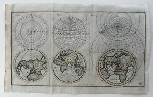
World in spheres 1799 map McIntyre north pole views measurement diagrams print

US $118.80
ApproximatelyRM 491.57
Was US $198.00 (40% off)
Condition:
“Uncommon/ scarce late 18th century world map of this era.
A visually superior example, clean, ”... Read moreabout condition
Sale ends in: 5d
Oops! Looks like we're having trouble connecting to our server.
Refresh your browser window to try again.
Shipping:
US $7.95 (approx RM 32.90) USPS Ground Advantage®.
Located in: Dover, New Hampshire, United States
Delivery:
Estimated between Mon, 17 Nov and Sat, 22 Nov to 94104
Returns:
30 days return. Buyer pays for return shipping. If you use an eBay shipping label, it will be deducted from your refund amount.
Coverage:
Read item description or contact seller for details. See all detailsSee all details on coverage
(Not eligible for eBay purchase protection programmes)
Shop with confidence
Seller assumes all responsibility for this listing.
eBay item number:197406772420
Item specifics
- Seller Notes
- Map View
- World
- Year
- 1799
Item description from the seller

Seller feedback (15,340)
- 1***1 (10)- Feedback left by buyer.Past monthVerified purchaseI ordered to prints from the seller-- both are absolutely lovely, and as described. Seller was responsive; when I asked if he could ship both prints together, he was happy to do so and refunded the price of shipping for one of the purchases. Prints were packaged well-- would buy from this seller again.
- k***k (311)- Feedback left by buyer.Past 6 monthsVerified purchasePlease note that I can never say enough about this seller, never missed a beat in all these years, communication exceptionally detailed, kudos and my gratitude and sincere appreciation! Expedient shipping, superb packaging, exactly as depicted and described and always good value.
- e***a (229)- Feedback left by buyer.Past 6 monthsVerified purchaseA++++, thank you! Map arrived exactly as described. Shipping and packaging were quick and secure, with a nice solid shipping tube provided for the rolled up map. Item itself was perfect; great detail, feel, and quality. Not sure about the value but I feel happy with my map so I'm saying it's a good value! Top notch sellerKholm Russia Soviet Union Novgorod Oblast c. 1943 WWII rare German topo map (#196949467890)
More to explore :
- 1700-1799 Antique World Atlas Maps,
- 1700-1799 Date Range World Atlas Antique North America Atlas Maps,
- Antique Original North America Maps 1700-1799,
- Antique World Maps & Atlases World 1700-1799 Date Range,
- World 1700-1799 Date Range Antique World Atlas Maps,
- 1700-1799 Date Range Antique World City Maps,
- 1700-1799 Date Range Antique World Folding Maps,
- 1700-1799 Date Range Antique North America Nautical Maps,
- Florida Antique North America Maps & Atlases 1700-1799 Date Range,
- North Polar Region Antique World Maps & Atlases
Seller feedback (15,340)
- 1***1 (10)- Feedback left by buyer.Past monthVerified purchaseI ordered to prints from the seller-- both are absolutely lovely, and as described. Seller was responsive; when I asked if he could ship both prints together, he was happy to do so and refunded the price of shipping for one of the purchases. Prints were packaged well-- would buy from this seller again.
- k***k (311)- Feedback left by buyer.Past 6 monthsVerified purchasePlease note that I can never say enough about this seller, never missed a beat in all these years, communication exceptionally detailed, kudos and my gratitude and sincere appreciation! Expedient shipping, superb packaging, exactly as depicted and described and always good value.
- e***a (229)- Feedback left by buyer.Past 6 monthsVerified purchaseA++++, thank you! Map arrived exactly as described. Shipping and packaging were quick and secure, with a nice solid shipping tube provided for the rolled up map. Item itself was perfect; great detail, feel, and quality. Not sure about the value but I feel happy with my map so I'm saying it's a good value! Top notch sellerKholm Russia Soviet Union Novgorod Oblast c. 1943 WWII rare German topo map (#196949467890)