Picture 1 of 8


Gallery
Picture 1 of 8


Have one to sell?
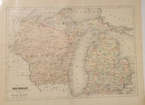
Antique copperplate hand colored map Michigan Wisconsin Johnson Cyclopaedia 1897
US $39.99
ApproximatelyRM 171.09
or Best Offer
Condition:
Oops! Looks like we're having trouble connecting to our server.
Refresh your browser window to try again.
Shipping:
Free USPS Media MailTM.
Located in: Lafayette, Colorado, United States
Delivery:
Estimated between Thu, 7 Aug and Mon, 11 Aug to 94104
Returns:
No returns accepted.
Coverage:
Read item description or contact seller for details. See all detailsSee all details on coverage
(Not eligible for eBay purchase protection programmes)
Seller assumes all responsibility for this listing.
eBay item number:196887320470
Item specifics
- Date Range
- 1850-1899
- Type
- County Map
- Format
- 2-page folded map
- Printing Technique
- Copperplate
- US State
- Michigan, Wisconsin
- Year
- 1897
- Original/Reproduction
- Antique Original
- Cartographer/Publisher
- Alvin Jewett Johnson
- Country/Region
- United States of America
Item description from the seller
Seller feedback (72)
- p***p (363)- Feedback left by buyer.Past monthVerified purchaseAs advertised!
- h***r (8186)- Feedback left by buyer.Past monthVerified purchaseSmooth fast 5-star T/A *****
- b***a (166)- Feedback left by buyer.Past monthVerified purchaseItem as descriptor. Good shipping
More to explore :
- Antique Wisconsin Maps & Atlases,
- Antique North America Michigan Maps,
- Wisconsin Topographical Map Antique North America Folding Maps,
- Wisconsin County Map Antique North America Folding Maps,
- Wisconsin County Map Antique North America Atlas Maps,
- Wisconsin Railroad Map Antique North America Atlas Maps,
- Wisconsin Antique North America Sheet Maps,
- Wisconsin Antique North America Topographical Maps,
- Wisconsin Antique Original Antique North America City Maps,
- Michigan Antique North America Atlas Maps