Picture 1 of 10


Gallery
Picture 1 of 10


Have one to sell?
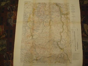
1907 Economic & Structural Map of Kenova Quadrangle Kentucky West Virginia Ohio

US $16.99
ApproximatelyRM 71.79
Condition:
“Folded as issued, super clean inside the border, Near Mint.”
Oops! Looks like we're having trouble connecting to our server.
Refresh your browser window to try again.
Shipping:
US $5.00 (approx RM 21.13) USPS First Class®.
Located in: Wilmington, North Carolina, United States
Delivery:
Estimated between Thu, 23 Oct and Tue, 28 Oct to 94104
Returns:
No returns accepted.
Coverage:
Read item description or contact seller for details. See all detailsSee all details on coverage
(Not eligible for eBay purchase protection programmes)
Seller assumes all responsibility for this listing.
eBay item number:194880986558
Item specifics
- Seller Notes
- “Folded as issued, super clean inside the border, Near Mint.”
- Cartographer/Publisher
- GPO
- Printing Technique
- Lithography
- Original/Reproduction
- Antique Original
- Format
- Folding Map
- Type
- Geological Economic Map
- Year
- 1907
- US State
- Kentucky, West Virginia, Ohio
- Date Range
- 1900-1909
- City
- Kenova Quad
- Country/Region
- United States of America
Item description from the seller

Seller feedback (4,003)
- *****- Feedback left by buyer.Past 6 monthsVerified purchaseVery good communication and timely transaction. Great offering and pricing. A quick shipper.
- *****- Feedback left by buyer.Past yearVerified purchaseMap was sent in a tube that couldn't cause damage to the map. The map was in great condition.
- *****- Feedback left by buyer.Past 6 monthsVerified purchaseItem was as described. It was packed well enough and shipped quickly. I believe it is a good value.
This is a private listing and your identity will not be disclosed to anyone except the seller.
More to explore :
- West Virginia Antique North America Maps & Atlases,
- West Virginia Topographical Map Antique North America Folding Maps,
- West Virginia Antique North America Topographical Maps,
- West Virginia Antique North America Railroad Maps,
- West Virginia Antique North America County Maps,
- West Virginia Vintage Original Antique North America Topographical Maps,
- West Virginia Antique Original Antique North America Folding Maps,
- United States of America West Virginia Antique North America Topographical Maps,
- West Virginia 1800-1899 Date Range Antique North America Railroad Maps,
- United States of America Lithography West Virginia Antique North America Maps & Atlases
Seller feedback (4,003)
- *****- Feedback left by buyer.Past 6 monthsVerified purchaseVery good communication and timely transaction. Great offering and pricing. A quick shipper.
- *****- Feedback left by buyer.Past yearVerified purchaseMap was sent in a tube that couldn't cause damage to the map. The map was in great condition.
- *****- Feedback left by buyer.Past 6 monthsVerified purchaseItem was as described. It was packed well enough and shipped quickly. I believe it is a good value.