Picture 1 of 10


Picture 1 of 10


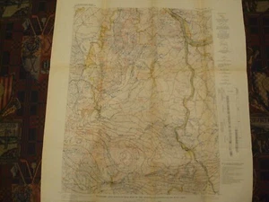
1907 Economic & Structural Map of Kenova Quadrangle Kentucky West Virginia Ohio

US $16.99
ApproximatelyRM 71.44
Condition:
“Folded as issued, super clean inside the border, Near Mint.”
Postage:
US $5.00 (approx RM 21.03) USPS First Class®.
Located in: Wilmington, North Carolina, United States
Delivery:
Estimated between Wed, 25 Sep and Fri, 27 Sep to 43230
Returns:
No returns accepted.
Coverage:
Read item description or contact seller for details. See all detailsSee all details on coverage
(Not eligible for eBay purchase protection programmes)
Seller assumes all responsibility for this listing.
eBay item number:194880986558
Item specifics
- Seller Notes
- “Folded as issued, super clean inside the border, Near Mint.”
- Cartographer/Publisher
- GPO
- Printing Technique
- Lithography
- Original/Reproduction
- Antique Original
- Format
- Folding Map
- Type
- Geological Economic Map
- Year
- 1907
- US State
- Kentucky, West Virginia, Ohio
- Date Range
- 1900-1909
- City
- Kenova Quad
- Country/Region
- United States of America
Item description from the seller

Seller feedback (3,913)
- 3***k (1929)- Feedback left by buyer.Past monthVerified purchaseThank you for extra care packing and shipping quickly.
- r***8 (106)- Feedback left by buyer.Past monthVerified purchaseThank you!
- 9***n (4)- Feedback left by buyer.Past monthVerified purchasejust a page out of an atlasReply from: thriftcanoe- Feedback replied by seller thriftcanoe.- Feedback replied by seller thriftcanoe.HI, Sorry your map did not meet your expectations. Please return map for a complete refund. No questions asked!!! SF
This is a private listing and your identity will not be disclosed to anyone except the seller.
More to explore :
- West Virginia Antique North America Maps & Atlases,
- West Virginia Antique North America Railroad Maps,
- West Virginia Topographical Map Antique North America Folding Maps,
- West Virginia Antique North America County Maps,
- West Virginia Antique North America Topographical Maps,
- West Virginia Original 1800-1899 Antique North America Maps & Atlases,
- West Virginia Rand McNally & Co. Antique North America Maps & Atlases,
- West Virginia Antique North American Maps & Atlases 1930-1939 Date Range,
- West Virginia 1800-1899 Date Range Antique North America County Maps,
- West Virginia Antique North American Maps & Atlases 1920-1929 Date Range