Picture 1 of 4


Gallery
Picture 1 of 4


Have one to sell?
Carto-bibliogr

GBP 50.00
ApproximatelyRM 281.92
or Best Offer
Condition:
Very Good
A book that has been read but is in excellent condition. No obvious damage to the cover, with the dust jacket included for hard covers. No missing or damaged pages, no creases or tears, and no underlining/highlighting of text or writing in the margins. May be very minimal identifying marks on the inside cover. Very minimal wear and tear.
Oops! Looks like we're having trouble connecting to our server.
Refresh your browser window to try again.
Shipping:
GBP 16.00 (approx RM 90.21) Royal Mail International Tracked.
Located in: Newhaven, United Kingdom
Delivery:
Estimated between Tue, 21 Oct and Sat, 1 Nov to 94104
Returns:
30 days return. Buyer pays for return shipping. If you use an eBay shipping label, it will be deducted from your refund amount.
Coverage:
Read item description or contact seller for details. See all detailsSee all details on coverage
(Not eligible for eBay purchase protection programmes)
Seller assumes all responsibility for this listing.
eBay item number:187016179525
Item specifics
- Condition
- Personalised
- No
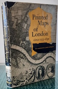
- Publication Name
- Printed Maps of London (1553-1850)
- Publisher
- George Philip & Son Ltd
- Item Length
- 18.5cm
- City
- London
- Subject
- Carto-bibliography
- Publication Year
- 1964
- Type
- Carto-bibliography
- Format
- Hardcover
- Language
- English
- Item Height
- 25cm
- Country
- United Kingdom
- Region
- Greater London
- Features
- Dust Jacket, Illustrated
- Country/Region of Manufacture
- United Kingdom
- Item Width
- 2.5cm
- Item Weight
- 1kg
- Number of Pages
- 260
Item description from the seller

Seller feedback (714)
- a***e (230)- Feedback left by buyer.Past 6 monthsVerified purchaseThis is my second contact with this seller. My opinion after the fiirst one was very positive. The item was delivered to Poland in relative short time and was in really good condition. This time I have ordered 3 items, combined delivery to UK. Delivery was immediate and the delivery cost was really low.Antique map, Dahlbergh/Pufendorf, Delineatio obsidionis urbis Stetini (Szczecin) (#186522557421)
- p***s (1796)- Feedback left by buyer.Past 6 monthsVerified purchaseVintage print as described in auction listing, well packaged and safely shipped. Very satisfactory transaction.Antique print, Bouanga, ou Espece de Pyrogue a trois rangs de rames. (#175799273411)
- a***z (3191)- Feedback left by buyer.Past 6 monthsVerified purchaseVery nice map. Seller could have packed the item a bit more securely but it arrived in good shape. Great eBayer!Antique map, Seutter / Lotter, c. 1744, Germaniae Aliorumque Quorundam Locorum . (#186131218435)
More to explore :
- London Maps & Atlases,
- Bibliographies, Indexes 1850-1899 Antiquarian & Collectible Books,
- Illustrated Bibliographies, Indexes 1850-1899 Antiquarian & Collectible Books,
- London Maps & Atlases in English,
- Bibliographies, Indexes Hardcover 1850-1899 Antiquarian & Collectible Books,
- 1st Edition Bibliographies, Indexes 1850-1899 Antiquarian & Collectible Books,
- Weekly Pre - 1850 Large Print Magazines,
- Women Pre - 1850 Large Print Magazines,
- Europe Antiquarian & Collectible Books 1850-1899 Printing Year,
- History Hardcover Antiquarian & Collectible Books 1850-1899 Printing Year
Seller feedback (714)
- a***e (230)- Feedback left by buyer.Past 6 monthsVerified purchaseThis is my second contact with this seller. My opinion after the fiirst one was very positive. The item was delivered to Poland in relative short time and was in really good condition. This time I have ordered 3 items, combined delivery to UK. Delivery was immediate and the delivery cost was really low.Antique map, Dahlbergh/Pufendorf, Delineatio obsidionis urbis Stetini (Szczecin) (#186522557421)
- p***s (1796)- Feedback left by buyer.Past 6 monthsVerified purchaseVintage print as described in auction listing, well packaged and safely shipped. Very satisfactory transaction.Antique print, Bouanga, ou Espece de Pyrogue a trois rangs de rames. (#175799273411)
- a***z (3191)- Feedback left by buyer.Past 6 monthsVerified purchaseVery nice map. Seller could have packed the item a bit more securely but it arrived in good shape. Great eBayer!Antique map, Seutter / Lotter, c. 1744, Germaniae Aliorumque Quorundam Locorum . (#186131218435)