Picture 1 of 12


Gallery
Picture 1 of 12


Have one to sell?
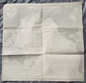
1887-1937 Pacific Ocean Map Admiralty Chart 39 1/2 X 40 inch W.J.L Wharton

US $99.00
ApproximatelyRM 419.38
or Best Offer
Condition:
“The condition is much like you see it in the photos. I count about 20 tack holes with about half ”... Read moreabout condition
Oops! Looks like we're having trouble connecting to our server.
Refresh your browser window to try again.
Pickup:
Free local pickup from Albany, Oregon, United States.
Delivery:
Varies
Returns:
No returns accepted.
Coverage:
Read item description or contact seller for details. See all detailsSee all details on coverage
(Not eligible for eBay purchase protection programmes)
Seller assumes all responsibility for this listing.
eBay item number:185621180001
Item specifics
- Seller Notes
- Year
- 1887
- Date Range
- 1930-1939
- Format
- Sheet Map
- Original/Reproduction
- Antique Original
Item description from the seller

Seller feedback (2,152)
- e***e (22911)- Feedback left by buyer.Past monthVerified purchaseThanks!
- 9***e (293)- Feedback left by buyer.Past monthVerified purchaseWhat a masterpiece great item and fast shipping
- y***t (4675)- Feedback left by buyer.Past monthVerified purchaseas described packed well shipped quick thank you
More to explore :
- Ocean Current Map Antique Atlas Maps,
- Antique Ocean Current Maps,
- Lithography Antique Ocean Current Maps,
- Antique World Ocean Current Maps,
- World Antique World Ocean Current Maps,
- Antique Original Antique World Ocean Current Maps,
- World Antique Original Antique World Ocean Current Maps,
- Antique Maritime Navigational Charts,
- United States Antique Maritime Navigational Charts,
- Vietnam War Antique Maritime Navigational Charts
Seller feedback (2,152)
- e***e (22911)- Feedback left by buyer.Past monthVerified purchaseThanks!
- 9***e (293)- Feedback left by buyer.Past monthVerified purchaseWhat a masterpiece great item and fast shipping
- y***t (4675)- Feedback left by buyer.Past monthVerified purchaseas described packed well shipped quick thank you