Picture 1 of 16


Gallery
Picture 1 of 16


Have one to sell?
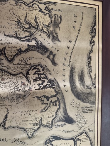
Virginia Jamestown Williamsburg Pictorial Color Map 1939 Robert Ball Restoration
US $150.00
ApproximatelyRM 636.48
Condition:
Oops! Looks like we're having trouble connecting to our server.
Refresh your browser window to try again.
Shipping:
US $11.89 (approx RM 50.45) USPS Priority Mail®.
Located in: Overland Park, Kansas, United States
Delivery:
Estimated between Mon, 4 Aug and Sat, 9 Aug to 94104
Returns:
No returns accepted.
Coverage:
Read item description or contact seller for details. See all detailsSee all details on coverage
(Not eligible for eBay purchase protection programmes)
Seller assumes all responsibility for this listing.
eBay item number:177155996387
Item specifics
- Date Range
- 1930-1939
- US State
- Virginia
- Year
- 1939
- City
- Jamestown
Item description from the seller
Seller feedback (105)
- z***l (901)- Feedback left by buyer.Past monthVerified purchaseGreat little car and very fast shipping! Very happy! Thanks!
- n***g (5)- Feedback left by buyer.Past monthVerified purchaseIt took a little long to get here. Not the best packeging I've seen, but the ítem is just as described, better condition than I expected. Drawer lining in great condition. Perfect restoration project. Thank you..!!
- r***t (1240)- Feedback left by buyer.Past monthVerified purchaseHad some issues: Seller took care of it. Made it right. No complaints. Fair and square. Solid customer service. A+
More to explore :
- Virginia Antique North America Maps & Atlases 1930-1939 Date Range,
- West Virginia Antique North American Maps & Atlases 1930-1939 Date Range,
- 1930-1939 Date Range Pictorial/Bird's Eye Antique North America Wall Maps,
- Antique North American Maps & Atlases Virginia,
- Virginia Topographical Map Antique North America Folding Maps,
- Virginia Topographical Map Antique North America Sheet Maps,
- Virginia Antique North America River Maps,
- West Virginia Antique North America Maps & Atlases,
- Pictorial/Bird's Eye Antique Wall Maps,
- 1930-1939 Date Range Folding Map River Map Antique Maps, Atlases & Globes