Picture 1 of 5


Gallery
Picture 1 of 5


Have one to sell?
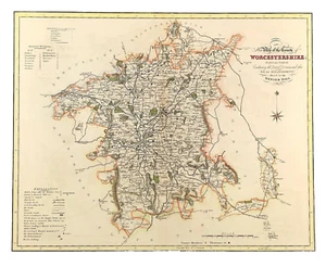
Worcestershire map towns, gentleman houses election poll reform bill 1833

GBP 98.00
ApproximatelyRM 535.21
Condition:
“Good Condition - Please see description below”
Oops! Looks like we're having trouble connecting to our server.
Refresh your browser window to try again.
Returns:
No returns accepted.
Coverage:
Read item description or contact seller for details. See all detailsSee all details on coverage
(Not eligible for eBay purchase protection programmes)
About this item
Seller assumes all responsibility for this listing.
eBay item number:167968980585
Item specifics
- Seller Notes
- “Good Condition - Please see description below”
- Date Range
- 1800-1899
- Type
- County Map
- Format
- Sheet Map
- Printing Technique
- Engraved
- Year
- 1833
- Region
- UK
- Cartographer/Publisher
- William Ebden & James Duncan
- Original/Reproduction
- Antique Original
- City
- Worcester
- County
- Worcestershire
- Map Type
- Historical/ Political
- Antique/ Modern
- Antique
Item description from the seller
Popular categories from this store
Seller feedback (1,884)
- 3***r (890)- Feedback left by buyer.Past 6 monthsVerified purchaseShipping: Perfect. USPS Priority. Packaging: In a good, sturdy tube. Came all the way with barely a dent. As described: YES. I surely got the better end of the deal. Value: For me, priceless. Thank you. I'll be looking for your items again. AND AND AND I avoided any tariff !!
- r***1 (162)- Feedback left by buyer.Past 6 monthsVerified purchaseExactly as described. Great communications, and fast shipping. If you are from the states, don’t let the tariff stuff dissuade you. Seller made it a seamless transaction. I’ll be shopping there again!Road Map London to Montgomery by Bowles original early 1782 (#167530988249)
- k***t (118)- Feedback left by buyer.Past monthVerified purchaseExcellent communication and packaging. The print was as described and it was a good value. Thank you!
More to explore :
- Antique European Maps & Atlases Worcestershire,
- Antique European Maps & Atlases England Worcestershire,
- Worcestershire Antique Original Antique European Maps & Atlases,
- Antique European Maps & Atlases Worcestershire 1800-1899 Date Range,
- Antique African Maps & Atlases Cape Town,
- Political Map Antique Atlas Maps,
- Topographical Map Antique Wall Maps,
- Political Map Antique Sheet Maps,
- Physical Map Antique Atlas Maps,
- Nautical Map Antique Folding Maps
Popular categories from this store
Seller feedback (1,884)
- 3***r (890)- Feedback left by buyer.Past 6 monthsVerified purchaseShipping: Perfect. USPS Priority. Packaging: In a good, sturdy tube. Came all the way with barely a dent. As described: YES. I surely got the better end of the deal. Value: For me, priceless. Thank you. I'll be looking for your items again. AND AND AND I avoided any tariff !!
- r***1 (162)- Feedback left by buyer.Past 6 monthsVerified purchaseExactly as described. Great communications, and fast shipping. If you are from the states, don’t let the tariff stuff dissuade you. Seller made it a seamless transaction. I’ll be shopping there again!Road Map London to Montgomery by Bowles original early 1782 (#167530988249)
- k***t (118)- Feedback left by buyer.Past monthVerified purchaseExcellent communication and packaging. The print was as described and it was a good value. Thank you!