Picture 1 of 4


Gallery
Picture 1 of 4


Have one to sell?
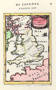
British Isles map by Mallet Saxon Heptarchy 1683 Original copperplate

GBP 78.00
ApproximatelyRM 425.98
Condition:
“Excellent overall condition - please see description below”
Oops! Looks like we're having trouble connecting to our server.
Refresh your browser window to try again.
Returns:
No returns accepted.
Coverage:
Read item description or contact seller for details. See all detailsSee all details on coverage
(Not eligible for eBay purchase protection programmes)
About this item
Seller assumes all responsibility for this listing.
eBay item number:167916333726
Item specifics
- Seller Notes
- “Excellent overall condition - please see description below”
- County
- Asia, Africa, Europe
- Region
- Eastern Hemisphere
- Cartographer/Publisher
- Allain Manesson Mallet / Johann David Zunner
- Printing Technique
- Copper Plate
- City
- London
- Date Range
- 1600-1699
- Original/Reproduction
- Antique Original
- Era
- 1600s
- Format
- Atlas Universal Dictionary Map
- COLOURING:
- Outline and wash Colour
- ORIGINAL / REPRO:
- Original
- Type
- Ancient Climate Map
- MAKER:
- Allain Manesson Mallet
- AGE:
- c1683
- SELLER NOTES:
- Excellent overall condition - See Description
- Year
- 1684
- Map Type
- English County Map
- Antique/ Modern
- Antique
Item description from the seller
Popular categories from this store
Seller feedback (1,884)
- 3***r (890)- Feedback left by buyer.Past 6 monthsVerified purchaseShipping: Perfect. USPS Priority. Packaging: In a good, sturdy tube. Came all the way with barely a dent. As described: YES. I surely got the better end of the deal. Value: For me, priceless. Thank you. I'll be looking for your items again. AND AND AND I avoided any tariff !!
- r***1 (162)- Feedback left by buyer.Past 6 monthsVerified purchaseExactly as described. Great communications, and fast shipping. If you are from the states, don’t let the tariff stuff dissuade you. Seller made it a seamless transaction. I’ll be shopping there again!Road Map London to Montgomery by Bowles original early 1782 (#167530988249)
- k***t (118)- Feedback left by buyer.Past monthVerified purchaseExcellent communication and packaging. The print was as described and it was a good value. Thank you!
More to explore :
- Isle of Wight Antique Original Antique Europe Maps & Atlases,
- Antique European Maps & Atlases Isle of Wight,
- British Columbia Antique Original Antique North America Atlas Maps,
- British Columbia Antique Original Antique North America Maps & Atlases,
- England Isle of Wight Antique Europe Maps & Atlases,
- Antique Original Railroad Map Antique Atlas Maps,
- Antique Original City Map Antique Atlas Maps,
- Antique Original Nautical Map Antique Folding Maps,
- Antique Original Railroad Map Antique Folding Maps,
- Antique Original River Map Antique Folding Maps
Popular categories from this store
Seller feedback (1,884)
- 3***r (890)- Feedback left by buyer.Past 6 monthsVerified purchaseShipping: Perfect. USPS Priority. Packaging: In a good, sturdy tube. Came all the way with barely a dent. As described: YES. I surely got the better end of the deal. Value: For me, priceless. Thank you. I'll be looking for your items again. AND AND AND I avoided any tariff !!
- r***1 (162)- Feedback left by buyer.Past 6 monthsVerified purchaseExactly as described. Great communications, and fast shipping. If you are from the states, don’t let the tariff stuff dissuade you. Seller made it a seamless transaction. I’ll be shopping there again!Road Map London to Montgomery by Bowles original early 1782 (#167530988249)
- k***t (118)- Feedback left by buyer.Past monthVerified purchaseExcellent communication and packaging. The print was as described and it was a good value. Thank you!