Picture 1 of 7


Gallery
Picture 1 of 7


Have one to sell?
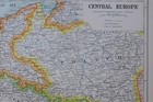
1919 MAP CENTRAL EUROPE POLAND CZECHOSLOVAKIA HUNGARY AUSTRIA GERMANY BELGIUM

GBP 68.00
ApproximatelyRM 387.56
or Best Offer
Condition:
“See images and description”
Oops! Looks like we're having trouble connecting to our server.
Refresh your browser window to try again.
Shipping:
GBP 15.00 (approx RM 85.49) Royal Mail International Tracked.
Located in: York, United Kingdom
Delivery:
Estimated between Mon, 18 Aug and Wed, 27 Aug to 94104
Returns:
No returns accepted.
Coverage:
Read item description or contact seller for details. See all detailsSee all details on coverage
(Not eligible for eBay purchase protection programmes)
Shop with confidence
Seller assumes all responsibility for this listing.
eBay item number:164428498400
Item specifics
- Seller Notes
- “See images and description”
- Format
- Atlas
- Year
- 1919
Item description from the seller

Seller feedback (20,462)
- a***t (318)- Feedback left by buyer.Past monthVerified purchaseThank you. Great item and well packed A+
- Automatische feedback van eBay- Feedback left by buyer.Past monthBestelling voltooid - getrackt en op tijd
- Automatische feedback van eBay- Feedback left by buyer.Past monthBestelling voltooid - getrackt en op tijd
More to explore :
- Belgium 1910-1919 Date Range Antique Europe Sheet Maps,
- Belgium 1910-1919 Date Range Antique Europe City Maps,
- Austria 1910-1919 Date Range Antique Europe City Maps,
- Belgium Antique Europe County Maps,
- Belgium Antique Europe Sheet Maps,
- Belgium Antique Europe Topographical Maps,
- Austria Antique Europe Topographical Maps,
- Poland Antique Europe County Maps,
- Hungary Antique Europe County Maps,
- Hungary Antique Europe Folding Maps
Seller feedback (20,462)
- a***t (318)- Feedback left by buyer.Past monthVerified purchaseThank you. Great item and well packed A+
- Automatische feedback van eBay- Feedback left by buyer.Past monthBestelling voltooid - getrackt en op tijd
- Automatische feedback van eBay- Feedback left by buyer.Past monthBestelling voltooid - getrackt en op tijd