
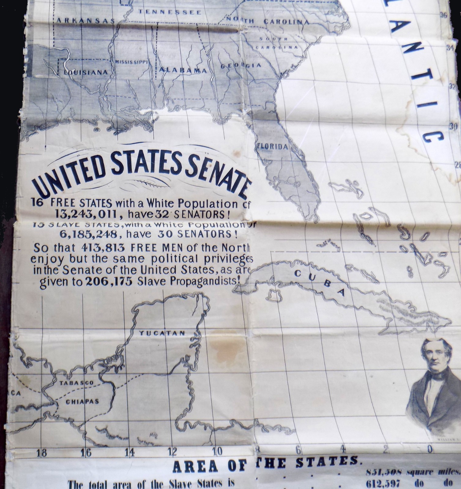
1850's FIRST REPUBLICAN John C. Fremont SLAVE STATES vs FREE STATES 54" WALL MAP
US $7,978.00US $7,978.00
Aug 17, 10:25Aug 17, 10:25
Picture 1 of 19


Gallery
Picture 1 of 19


Have one to sell?
1850's FIRST REPUBLICAN John C. Fremont SLAVE STATES vs FREE STATES 54" WALL MAP
MISSOURI COMPROMISE LINE, Hand Colored Hand Written Spc

Condition:
“Rare 54-inch map backed with a heavy almost canvas-like stock. Map depicts the FREE and SLAVE hand ”... Read moreabout condition
Ended: Aug 17, 2025 10:25:01 MYT
Oops! Looks like we're having trouble connecting to our server.
Refresh your browser window to try again.
Shipping:
US $18.95 (approx RM 80.14) USPS Priority Mail®.
Located in: Manchester, New Hampshire, United States
Delivery:
Estimated between Sat, 13 Sep and Fri, 19 Sep to 94104
Returns:
No returns accepted.
Coverage:
Read item description or contact seller for details. See all detailsSee all details on coverage
(Not eligible for eBay purchase protection programmes)
Seller assumes all responsibility for this listing.
eBay item number:157224815841
Item specifics
- Seller Notes
- Date Range
- 1800-1899
- Type
- Political Map
- Format
- Wall Map
- Year
- 1856
- Original/Reproduction
- Antique Original
- Country/Region
- United States of America
Item description from the seller

Seller feedback (6,333)
This item (1)
All items (6,333)
- eBay automated feedback- Feedback left by buyer.Past monthOrder completed successfully—tracked and on time
- 8***3 (593)- Feedback left by buyer.Past monthVerified purchasegood saller
- eBay automated feedback- Feedback left by buyer.Past monthOrder completed successfully—tracked and on time
- eBay automated feedback- Feedback left by buyer.Past monthOrder completed successfully—tracked and on time
More to explore :
- United States of America Topographical Map Antique North America Wall Maps,
- United States of America County Map Antique North America Wall Maps,
- United States of America Nautical Map Antique North America Wall Maps,
- United States of America Political Map Antique North America Wall Maps,
- United States of America Antique North America Wall Maps,
- Stately 1850-1899 Silver Antiques,
- John Bartholomew United States of America Antique North American Maps & Atlases,
- United States of America Vintage Original Antique North America Wall Maps,
- United States of America Political Map Antique North America Sheet Maps,
- United States of America County Map Antique North America Atlas Maps
Seller feedback (6,333)
This item (1)
All items (6,333)
- eBay automated feedback- Feedback left by buyer.Past monthOrder completed successfully—tracked and on time
- 8***3 (593)- Feedback left by buyer.Past monthVerified purchasegood saller
- eBay automated feedback- Feedback left by buyer.Past monthOrder completed successfully—tracked and on time
- eBay automated feedback- Feedback left by buyer.Past monthOrder completed successfully—tracked and on time