
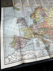
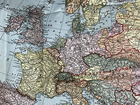
Antique 1919 WWI Treaty Boundry Map New Europe Rand-McNally Axis Allies 26" Old
US $69.97US $69.97
May 21, 13:58May 21, 13:58
Picture 1 of 24


Gallery
Picture 1 of 24


Have one to sell?
Antique 1919 WWI Treaty Boundry Map New Europe Rand-McNally Axis Allies 26" Old
US $69.97
ApproximatelyRM 295.87
or Best Offer
Was US $99.95 (30% off)
Condition:
“Approx 26" x 26" WHOLE folded out, actual map (without text) approx 26" x 19" , shows boundries ”... Read moreabout condition
Ended: May 21, 2025 13:58:00 MYT
Oops! Looks like we're having trouble connecting to our server.
Refresh your browser window to try again.
Pickup:
Free local pickup from Kunkletown, Pennsylvania, United States.
Shipping:
US $6.75 (approx RM 28.54) Standard Shipping.
Located in: Kunkletown, Pennsylvania, United States
Delivery:
Estimated between Sat, 9 Aug and Fri, 15 Aug to 94104
Returns:
30 days return. Buyer pays for return shipping. If you use an eBay shipping label, it will be deducted from your refund amount.
Coverage:
Read item description or contact seller for details. See all detailsSee all details on coverage
(Not eligible for eBay purchase protection programmes)
Seller assumes all responsibility for this listing.
eBay item number:156862196985
Item specifics
- Seller Notes
- Date Range
- 1910-1919
- Type
- Post WW1 Treaty New Boundry Lines Political Map
- Format
- Folding Map
- Year
- 1919
- Original/Reproduction
- Antique Original
- Cartographer/Publisher
- Rand McNally & Co.
- Country/Region
- Belgium, France, Germany, Hungary, Netherlands, Ukraine, Soviet Union Russia, WW1 Europe
Item description from the seller
Seller Feedback
No feedback yet
More to explore :
- Rand McNally & Co. Antique Europe Atlas Maps,
- Rand McNally & Co. Antique Original Antique Europe Maps & Atlases,
- Rand McNally & Co. Antique Original Antique Europe Atlas Maps,
- Rand McNally & Co. 1910-1919 Date Range Antique City Maps,
- Rand McNally & Co. 1910-1919 Date Range Antique Topographical Maps,
- Rand McNally & Co. Antique Wall Maps,
- Rand McNally & Co. City Map Antique Folding Maps,
- Rand McNally & Co. Physical Map Antique Atlas Maps,
- Rand McNally & Co. Antique European Maps & Atlases,
- Rand McNally & Co. Antique World Wall Maps