Picture 1 of 8


Gallery
Picture 1 of 8


Have one to sell?
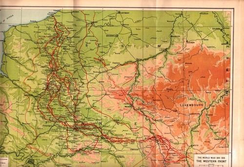
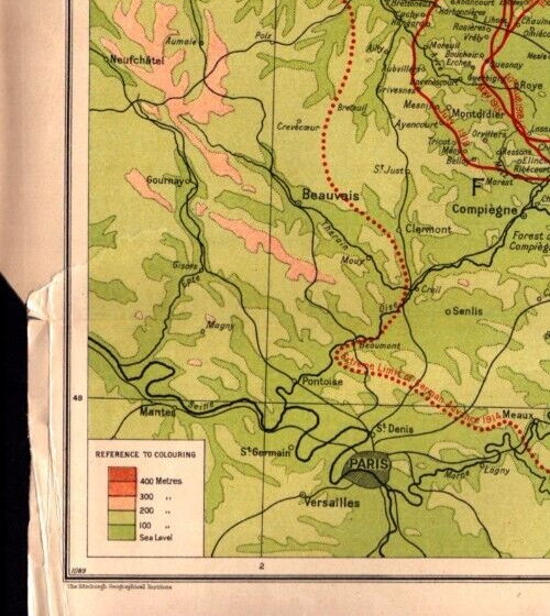
"THE WESTERN FRONT" WWI, FRANCE, LUXEMBOURG, BELGIUM Antique original map c1920

US $75.00
ApproximatelyRM 311.96
Condition:
“Authentic original map.”
Oops! Looks like we're having trouble connecting to our server.
Refresh your browser window to try again.
Shipping:
US $5.85 (approx RM 24.33) USPS Ground Advantage®.
Located in: Navarre, Florida, United States
Delivery:
Estimated between Sat, 15 Nov and Thu, 20 Nov
Returns:
30 days return. Seller pays for return shipping.
Coverage:
Read item description or contact seller for details. See all detailsSee all details on coverage
(Not eligible for eBay purchase protection programmes)
Seller assumes all responsibility for this listing.
eBay item number:156680291964
Item specifics
- Seller Notes
- “Authentic original map.”
- Date Range
- 1900-1909
- Type
- Topographical Map
- Format
- Atlas Map
- Printing Technique
- Lithography
- Original/Reproduction
- Antique Original
- Cartographer/Publisher
- John George Bartholomew and Son
- City
- Paris
- Country/Region
- FRANCE, LUXEMBOURG, BELGIUM
Item description from the seller

Seller feedback (647)
- 8***m (156)- Feedback left by buyer.Past yearVerified purchaseThis seller provided a flawless experience! Shipping was incredibly fast, with accurate tracking and on-time delivery. The packaging was secure and well-protected, ensuring the item arrived in perfect condition. The product matched the listing exactly—no surprises, just great quality. The price was fair, making this a fantastic value. Honest, reliable, and professional, this seller exceeded expectations. Highly recommended—I’ll definitely buy again!Reply from: perdueantiquemapdealer- Feedback replied by seller perdueantiquemapdealer.- Feedback replied by seller perdueantiquemapdealer.Excellent! Thank you.McALESTER-LEHIGH COAL FIELD, COALGATE, OKLAHOMA Antique geology map 1899 (#156620828859)
- r***e (134)- Feedback left by buyer.Past monthVerified purchaseExcellent seller! The item arrived quickly and was exactly as described. It was very well packaged, and the communication throughout the process was friendly and helpful. I would definitely buy from this seller again. Highly recommended!
- c***t (1550)- Feedback left by buyer.Past 6 monthsVerified purchaseVery pleased with purchase! Exactly as described. packed well for shipping. Seller is on top of things,great communication. Would buy from again. Highly recommend!MT. RAINIER PROPOSED NATIONAL PARK, FOREST RESERVE, WASHINGTON Antique map 1898 (#156670854432)
More to explore :
- Belgium Antique Original Antique European Maps & Atlases,
- Belgium Antique Original Antique Europe County Maps,
- Belgium Antique Original Antique Europe Folding Maps,
- Belgium Antique Original Antique Europe Sheet Maps,
- Belgium Antique Original Antique Europe Atlas Maps,
- Belgium Ghent Antique Original Antique European Maps & Atlases,
- Belgium Liège Antique Original Antique European Maps & Atlases,
- France Antique Original Antique Europe County Maps,
- France Antique Original Antique Europe Topographical Maps,
- France Antique Original Antique Europe Railroad Maps
Seller feedback (647)
- 8***m (156)- Feedback left by buyer.Past yearVerified purchaseThis seller provided a flawless experience! Shipping was incredibly fast, with accurate tracking and on-time delivery. The packaging was secure and well-protected, ensuring the item arrived in perfect condition. The product matched the listing exactly—no surprises, just great quality. The price was fair, making this a fantastic value. Honest, reliable, and professional, this seller exceeded expectations. Highly recommended—I’ll definitely buy again!Reply from: perdueantiquemapdealer- Feedback replied by seller perdueantiquemapdealer.- Feedback replied by seller perdueantiquemapdealer.Excellent! Thank you.McALESTER-LEHIGH COAL FIELD, COALGATE, OKLAHOMA Antique geology map 1899 (#156620828859)
- r***e (134)- Feedback left by buyer.Past monthVerified purchaseExcellent seller! The item arrived quickly and was exactly as described. It was very well packaged, and the communication throughout the process was friendly and helpful. I would definitely buy from this seller again. Highly recommended!
- c***t (1550)- Feedback left by buyer.Past 6 monthsVerified purchaseVery pleased with purchase! Exactly as described. packed well for shipping. Seller is on top of things,great communication. Would buy from again. Highly recommend!MT. RAINIER PROPOSED NATIONAL PARK, FOREST RESERVE, WASHINGTON Antique map 1898 (#156670854432)