Picture 1 of 1
Gallery
Picture 1 of 1

Have one to sell?
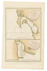
1798 La Perouse Map and Chart of San Diego; Earliest Map of San Diego Bay

US $500.00
ApproximatelyRM 2,112.85
or Best Offer
Condition:
“Very good. Minor foxing. 29 x 46 cm (11.5 x 18.25 in)”
Oops! Looks like we're having trouble connecting to our server.
Refresh your browser window to try again.
Shipping:
US $30.00 (approx RM 126.77) FedEx Ground / FedEx Home Delivery®.
Located in: Belvedere Tiburon, California, United States
Delivery:
Estimated between Fri, 24 Oct and Tue, 28 Oct to 94104
Returns:
14 days return. Buyer pays for return shipping. If you use an eBay shipping label, it will be deducted from your refund amount.
Coverage:
Read item description or contact seller for details. See all detailsSee all details on coverage
(Not eligible for eBay purchase protection programmes)
Seller assumes all responsibility for this listing.
eBay item number:146728494214
Item specifics
- Seller Notes
- “Very good. Minor foxing. 29 x 46 cm (11.5 x 18.25 in)”
- Date Range
- 1700-1799
- US State
- California
- Printing Technique
- Copper Plate
- Year
- 1798
- Original/Reproduction
- Antique Original
- Cartographer/Publisher
- La Perouse
- City
- San Diego
- Country/Region
- United States of America
Item description from the seller

Seller feedback (41)
- k***e (455)- Feedback left by buyer.Past 6 monthsVerified purchaseThe shipping and packaging were excellent. The Birdseye view was as described and at a good price. Thank you Michael for such an excellent and beautiful view.
- w***a (834)- Feedback left by buyer.Past 6 monthsVerified purchaseGreat vendor! A++++ Excellent packaging. Wonderful item.
- a***i (13977)- Feedback left by buyer.Past 6 monthsVerified purchaseGreat seller, wonderful item and shipped quickly. Thanks!!c. 1930s Promotional Real Estate Booklet, Maps - Buena Vista Santa Barbara, CA (#146688447087)
More to explore :
- Antique North American Maps & Atlases San Diego,
- San Diego California American Antique Maps & Atlases,
- San Diego Antique North American Maps & Atlases 1800-1899 Date Range,
- San Francisco Oregon American Antique Maps & Atlases,
- San Francisco California American Antique Maps & Atlases,
- San Francisco Antique North America Railroad Maps,
- San Francisco California Antique North America Folding Maps,
- San Francisco Antique Original Antique North America Sheet Maps,
- San Francisco Antique Original Antique North America City Maps,
- San Francisco California Vintage Original Antique North American Maps & Atlases
Seller feedback (41)
- k***e (455)- Feedback left by buyer.Past 6 monthsVerified purchaseThe shipping and packaging were excellent. The Birdseye view was as described and at a good price. Thank you Michael for such an excellent and beautiful view.
- w***a (834)- Feedback left by buyer.Past 6 monthsVerified purchaseGreat vendor! A++++ Excellent packaging. Wonderful item.
- a***i (13977)- Feedback left by buyer.Past 6 monthsVerified purchaseGreat seller, wonderful item and shipped quickly. Thanks!!c. 1930s Promotional Real Estate Booklet, Maps - Buena Vista Santa Barbara, CA (#146688447087)