Picture 1 of 1
Gallery
Picture 1 of 1

Have one to sell?
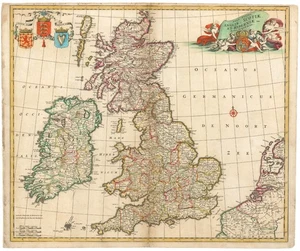
c. 1680 de Wit Map of British Isles 'Nova totius Angliae, Scotiae et Hiberniae'

US $450.00
ApproximatelyRM 1,911.92
or Best Offer
Condition:
“Various repairs and infill, and other blemishes. Nice old color. 57 x 48 cm (22.5 x 19 in)”
Oops! Looks like we're having trouble connecting to our server.
Refresh your browser window to try again.
Shipping:
US $30.00 (approx RM 127.46) FedEx Ground or FedEx Home Delivery®.
Located in: Belvedere Tiburon, California, United States
Delivery:
Estimated between Tue, 22 Jul and Mon, 28 Jul to 94104
Returns:
14 days return. Buyer pays for return shipping. If you use an eBay shipping label, it will be deducted from your refund amount.
Coverage:
Read item description or contact seller for details. See all detailsSee all details on coverage
(Not eligible for eBay purchase protection programmes)
Seller assumes all responsibility for this listing.
eBay item number:146715709324
Item specifics
- Seller Notes
- “Various repairs and infill, and other blemishes. Nice old color. 57 x 48 cm (22.5 x 19 in)”
- Date Range
- 1600-1699
- Printing Technique
- Copper Plate
- Format
- Atlas Map
- Year
- 1680
- Original/Reproduction
- Antique Original
- Cartographer/Publisher
- Frederik de Wit
- Country/Region
- England, Ireland, Scotland, United Kingdom
Item description from the seller

Seller feedback (34)
- a***i (13865)- Feedback left by buyer.Past monthVerified purchaseGreat seller, wonderful item and shipped quickly. Thanks!!
- s***w (9777)- Feedback left by buyer.Past monthVerified purchaseprompt payment!
- 2***m (89)- Feedback left by buyer.Past yearVerified purchaseExcellent to work with. Item was exactly as described. Would definitely work with this seller again.[Sutro Baths] ON THE SHORE OF THE PACIFIC OCEAN (#145422041115)
More to explore :
- Antique North American Maps & Atlases Nova Scotia,
- Nova Scotia Antique North America County Maps,
- Nova Scotia Political Map Antique North America Atlas Maps,
- Nova Scotia Antique North America Atlas Maps,
- Nova Scotia Antique North America Folding Maps,
- Nova Scotia Campeche Antique North America Maps & Atlases,
- Nova Scotia Halifax Antique North America Maps & Atlases,
- Nova Scotia Aguascalientes Antique North America Maps & Atlases,
- Nova Scotia Coahuila Antique North America Maps & Atlases,
- Nova Scotia California Antique North America Maps & Atlases
Seller feedback (34)
- a***i (13865)- Feedback left by buyer.Past monthVerified purchaseGreat seller, wonderful item and shipped quickly. Thanks!!
- s***w (9777)- Feedback left by buyer.Past monthVerified purchaseprompt payment!
- 2***m (89)- Feedback left by buyer.Past yearVerified purchaseExcellent to work with. Item was exactly as described. Would definitely work with this seller again.[Sutro Baths] ON THE SHORE OF THE PACIFIC OCEAN (#145422041115)