Picture 1 of 6


Gallery
Picture 1 of 6


Have one to sell?
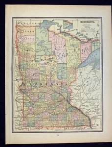
1889 State of Minnesota and North Dakota Antique Map

US $10.95
ApproximatelyRM 46.85
or Best Offer
Condition:
“Good condition (see photos).”
Oops! Looks like we're having trouble connecting to our server.
Refresh your browser window to try again.
Shipping:
US $8.75 (approx RM 37.43) USPS Ground Advantage®.
Located in: Corunna, Michigan, United States
Delivery:
Estimated between Thu, 7 Aug and Tue, 12 Aug to 94104
Returns:
30 days return. Seller pays for return shipping.
Coverage:
Read item description or contact seller for details. See all detailsSee all details on coverage
(Not eligible for eBay purchase protection programmes)
Seller assumes all responsibility for this listing.
eBay item number:145867712997
Item specifics
- Seller Notes
- “Good condition (see photos).”
- Date Range
- 1800-1899
- Type
- World Atlas
- Format
- Atlas
- Printing Technique
- Lithography
- US State
- Minnesota, North Dakota
- Year
- 1889
- Original/Reproduction
- Antique Original
- Cartographer/Publisher
- George Cram
Item description from the seller

Seller feedback (10,143)
- g***r (1116)- Feedback left by buyer.Past monthVerified purchaseNice car!
- g***r (1116)- Feedback left by buyer.Past monthVerified purchaseVery good seller!
- g***r (1116)- Feedback left by buyer.Past monthVerified purchaseNice car!
More to explore :
- United States of America Minnesota Antique North America City Maps,
- United States of America Minnesota Antique North America Maps & Atlases,
- United States of America Minnesota Antique North America Topographical Maps,
- United States of America Minnesota Antique North America Folding Maps,
- United States of America Minnesota Antique North America Atlas Maps,
- Minnesota Antique North America County Maps,
- Minnesota Antique North America River Maps,
- Minnesota Railroad Map Antique North America Atlas Maps,
- Minnesota County Map Antique North America Atlas Maps,
- North Dakota Topographical Map Antique North America Folding Maps
Seller feedback (10,143)
- g***r (1116)- Feedback left by buyer.Past monthVerified purchaseNice car!
- g***r (1116)- Feedback left by buyer.Past monthVerified purchaseVery good seller!
- g***r (1116)- Feedback left by buyer.Past monthVerified purchaseNice car!