Picture 1 of 22


Gallery
Picture 1 of 22


Have one to sell?
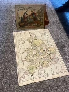
Map of England & Wales Superior Dissected Maps Gall and Inglis Antique Victorian
GBP 200.00
ApproximatelyRM 1,136.21
or Best Offer
Condition:
Oops! Looks like we're having trouble connecting to our server.
Refresh your browser window to try again.
Shipping:
GBP 25.00 (approx RM 142.03) Standard Int'l Postage.
Located in: Harrogate, United Kingdom
Delivery:
Estimated between Tue, 23 Sep and Tue, 7 Oct to 94104
Returns:
No returns accepted.
Coverage:
Read item description or contact seller for details. See all detailsSee all details on coverage
(Not eligible for eBay purchase protection programmes)
Shop with confidence
Seller assumes all responsibility for this listing.
eBay item number:136269159084
Item specifics
- Antique
- Yes
- Date Range
- 1800-1899
- Type
- Physical Map
- Era
- 1800s
- Original/Reproduction
- Antique Original
Item description from the seller
Seller business information
VAT number: GB 479926030
Seller feedback (878)
- eBay automated Feedback- Feedback left by buyer.Past monthOrder completed successfully – tracked and on time
- eBay automated Feedback- Feedback left by buyer.Past monthOrder completed successfully – tracked and on time
- *****- Feedback left by buyer.Past monthVerified purchaseExcellent packing, item as described, beautiful, thank you so much
This is a private listing and your identity will not be disclosed to anyone except the seller.
More to explore :
- Wales Antique Europe Railroad Maps,
- Wales Antique Europe Sheet Maps,
- Wales Antique Europe Folding Maps,
- Wales Antique Europe Maps & Atlases,
- Wales Antique Europe Atlas Maps,
- Antique European Maps & Atlases Wales Cornwall,
- Antique European Maps & Atlases Wales Lithography,
- Wales London Antique Europe Atlas Maps,
- England Antique Europe Maps & Atlases,
- England Antique Europe Sheet Maps