Picture 1 of 4


Gallery
Picture 1 of 4


Have one to sell?
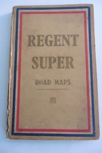
Regent Super Road map 1930's

GBP 60.00
ApproximatelyRM 340.43
or Best Offer
Condition:
“Good overall condition - damage to spine but free from sellotape so could be restored easily”
Oops! Looks like we're having trouble connecting to our server.
Refresh your browser window to try again.
Shipping:
GBP 23.07 (approx RM 130.90) International Priority Shipping to United States via eBay's Global Shipping Program.
Located in: Cheltenham, United Kingdom
Import charges:
Free amount confirmed at checkout
Delivery:
Estimated between Thu, 30 Oct and Fri, 7 Nov to 94104
Includes international tracking
Returns:
No returns accepted.
Coverage:
Read item description or contact seller for details. See all detailsSee all details on coverage
(Not eligible for eBay purchase protection programmes)
Seller assumes all responsibility for this listing.
eBay item number:135615468770
Item specifics
- Seller Notes
- “Good overall condition - damage to spine but free from sellotape so could be restored easily”
- Antique
- Yes
- Date Range
- 1930-1939
- Era
- 1930s
- Cartographer/Publisher
- Edward Stanford
- Original/Reproduction
- Vintage Original
Item description from the seller

Seller feedback (896)
- *****- Feedback left by buyer.Past 6 monthsVerified purchaseItem as described, well packaged with prompt delivery A***** ebayer
- *****- Feedback left by buyer.Past monthVerified purchaseExcellent quality, new as stated, really good value for money and just perfect in appearance. Fast delivery and seller had excellent communication. Totally recommend
- *****- Feedback left by buyer.Past 6 monthsVerified purchaseGreat quality waistcoat. Good communication. Well packaged. Would happily deal with this seller again.
More to explore :
- 1930-1939 Date Range County Map Antique Folding Maps,
- 1930-1939 Date Range Folding Map River Map Antique Maps, Atlases & Globes,
- Physical Map Sheet Map Antique 1930-1939 Date Range Maps, Atlases & Globes,
- Atlas Map City Map 1930-1939 Date Range Antique Maps, Atlases & Globes,
- 1930-1939 Date Range Sheet Map Topographical Map Antique Maps, Atlases & Globes,
- 1930-1939 Date Range Antique School Maps,
- 1930-1939 Date Range Antique Wall Maps,
- 1930-1939 Date Range County Map Antique North America Folding Maps,
- Antique European Maps & Atlases 1930-1939 Date Range,
- Lithography 1930-1939 Date Range Antique City Maps
Seller feedback (896)
- *****- Feedback left by buyer.Past 6 monthsVerified purchaseItem as described, well packaged with prompt delivery A***** ebayer
- *****- Feedback left by buyer.Past monthVerified purchaseExcellent quality, new as stated, really good value for money and just perfect in appearance. Fast delivery and seller had excellent communication. Totally recommend
- *****- Feedback left by buyer.Past 6 monthsVerified purchaseGreat quality waistcoat. Good communication. Well packaged. Would happily deal with this seller again.