Picture 1 of 9


Gallery
Picture 1 of 9


Have one to sell?
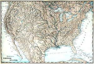
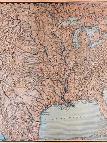
1909 United States Topographical Map

US $60.00
ApproximatelyRM 252.45
or Best Offer
Condition:
“Very Good with very slight wear around the edges.”
Oops! Looks like we're having trouble connecting to our server.
Refresh your browser window to try again.
Shipping:
US $10.00 (approx RM 42.08) USPS Ground Advantage®.
Located in: Aransas Pass, Texas, United States
Delivery:
Estimated between Fri, 29 Aug and Sat, 6 Sep to 94104
Returns:
30 days return. Buyer pays for return shipping. If you use an eBay shipping label, it will be deducted from your refund amount.
Coverage:
Read item description or contact seller for details. See all detailsSee all details on coverage
(Not eligible for eBay purchase protection programmes)
Seller assumes all responsibility for this listing.
eBay item number:135042259835
Item specifics
- Seller Notes
- “Very Good with very slight wear around the edges.”
- Date Range
- 1900-1909
- Type
- Topographical Map
- US State
- All 48 States
- Format
- Folding Map
- Printing Technique
- Lithography
- Mexican State
- NA
- Year
- 1909
- Canadian Province
- NA
- Cartographer/Publisher
- George Cram
- City
- New York
- Country/Region
- United States of America
Item description from the seller

Popular categories from this store
Seller feedback (304)
- r***r (1178)- Feedback left by buyer.Past monthVerified purchaseA true professional! Goes above and beyond to help the buyer. It doesn’t get any better than this. A+
- 3***n (914)- Feedback left by buyer.Past monthVerified purchaseShop with confidence as this seller is quick to respond, fast shipping and packaged properly. Item arrived quickly and as described. This was a great experience with this seller. A+++ PURCHASE.
- c***3 (214)- Feedback left by buyer.Past monthVerified purchaseLove the ring! Thought it was going to be too big but it’s perfect.
More to explore :
- United States of America Topographical Map Antique North America Wall Maps,
- United States of America Topographical Map Antique North America Atlas Maps,
- United States of America Antique North America Topographical Maps,
- United States of America Topographical Map Antique North America Sheet Maps,
- 1900-1909 Date Range Antique Topographical Maps,
- United States of America Wyoming Antique North America Topographical Maps,
- United States of America Colorado Antique North America Topographical Maps,
- United States of America North Carolina Antique North America Topographical Maps,
- 1900-1909 Date Range Sheet Map Topographical Map Antique Maps, Atlases & Globes,
- Atlas Map Topographical Map 1900-1909 Date Range Antique Maps, Atlases & Globes
Popular categories from this store
Seller feedback (304)
- r***r (1178)- Feedback left by buyer.Past monthVerified purchaseA true professional! Goes above and beyond to help the buyer. It doesn’t get any better than this. A+
- 3***n (914)- Feedback left by buyer.Past monthVerified purchaseShop with confidence as this seller is quick to respond, fast shipping and packaged properly. Item arrived quickly and as described. This was a great experience with this seller. A+++ PURCHASE.
- c***3 (214)- Feedback left by buyer.Past monthVerified purchaseLove the ring! Thought it was going to be too big but it’s perfect.