Picture 1 of 2

Gallery
Picture 1 of 2


Have one to sell?
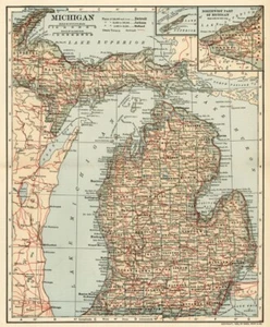
MICHIGAN Map: Authentic 1906 (dated) with Counties, Towns, Topography, Railroads

US $34.34
ApproximatelyRM 144.79
or Best Offer
Condition:
Oops! Looks like we're having trouble connecting to our server.
Refresh your browser window to try again.
Shipping:
Free USPS First Class®.
Located in: Iowa City, Iowa, United States
Delivery:
Estimated between Wed, 15 Oct and Tue, 21 Oct
Returns:
14 days return. Buyer pays for return shipping. If you use an eBay shipping label, it will be deducted from your refund amount.
Coverage:
Read item description or contact seller for details. See all detailsSee all details on coverage
(Not eligible for eBay purchase protection programmes)
Seller assumes all responsibility for this listing.
eBay item number:134992857409
Item specifics
- US State
- Michigan
- Format
- Atlas Map
- Original/Reproduction
- Original
- Date Range
- 1900-1909
- Country/Region
- United States of America
- Printing Technique
- Lithography
- Year
- 1906
- Publication Year
- 1907
- North America States & Provinces
- Michigan
- Era
- 1900s
Item description from the seller

Popular categories from this store
Seller feedback (25,034)
- Évaluations automatiques eBay- Feedback left by buyer.Past monthCommande livrée dans les délais et sans problème
- i***s (41)- Feedback left by buyer.Past 6 monthsVerified purchaseexcellent experience, highly recommend.
- e***b (1965)- Feedback left by buyer.Past 6 monthsVerified purchaseCheers ! Arrived safelyKitty Starling Dancer 1914 Ad Ludwig Hohlwein 1926 Sepia Photogravure Print (#363284634260)
More to explore :
- Michigan 1800-1899 Date Range Antique North America County Maps,
- Michigan 1900-1909 Date Range Antique North America County Maps,
- Michigan 1400-1499 Date Range Antique North America County Maps,
- Michigan 1920-1929 Date Range Antique North America County Maps,
- Michigan 1950-1959 Date Range Antique North America County Maps,
- Michigan Lithography Antique North America County Maps,
- Michigan 1800-1899 Date Range Antique North America Railroad Maps,
- 1970-1979 Date Range Antique County Maps,
- 1930-1939 Date Range County Map Antique Folding Maps,
- 1980-1989 Date Range Antique County Maps
Popular categories from this store
Seller feedback (25,034)
- Évaluations automatiques eBay- Feedback left by buyer.Past monthCommande livrée dans les délais et sans problème
- i***s (41)- Feedback left by buyer.Past 6 monthsVerified purchaseexcellent experience, highly recommend.
- e***b (1965)- Feedback left by buyer.Past 6 monthsVerified purchaseCheers ! Arrived safelyKitty Starling Dancer 1914 Ad Ludwig Hohlwein 1926 Sepia Photogravure Print (#363284634260)