Picture 1 of 1
Gallery
Picture 1 of 1

Have one to sell?
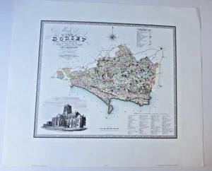
Antique Map of- COUNTY OF DORSET 1825-1826 LONDON C & J GREENWOOD copy

GBP 15.99
ApproximatelyRM 91.32
Condition:
“new”
Oops! Looks like we're having trouble connecting to our server.
Refresh your browser window to try again.
Shipping:
GBP 17.40 (approx RM 99.37) International Priority Shipping to United States via eBay's Global Shipping Program.
Located in: Blackmore Vale, Dorset, United Kingdom
Import charges:
Free amount confirmed at checkout
Delivery:
Estimated between Tue, 29 Jul and Thu, 7 Aug to 94104
Includes international tracking
Returns:
No returns accepted.
Coverage:
Read item description or contact seller for details. See all detailsSee all details on coverage
(Not eligible for eBay purchase protection programmes)
Seller assumes all responsibility for this listing.
eBay item number:127223056928
Item specifics
- Seller Notes
- “new”
- Date Range
- 1800-1899
- Type
- County Map
- Printing Technique
- Lithography
- Year
- 1826
- Original/Reproduction
- modern copy
- County
- Dorset
Item description from the seller

Seller feedback (4,290)
- eBay automated feedback- Feedback left by buyer.Past monthOrder completed successfully—tracked and on time
- e***e (5602)- Feedback left by buyer.Past monthVerified purchaseItem as described, very well packed, super speedy delivery, great 5* customer service - thank you so much for listing this item.
- eBay automated feedback- Feedback left by buyer.Past monthOrder completed successfully—tracked and on time
More to explore :
- London London Antique Europe County Maps,
- London Antique Europe County Maps,
- London Antique Original Antique Europe County Maps,
- Antique County Maps,
- Antique European Maps & Atlases Dorset,
- County Map Antique Wall Maps,
- County Map Antique Atlas,
- Antique Europe County Maps,
- London 1700-1799 Date Range Antique Europe County Maps,
- Lithography County Map Antique Sheet Maps
Seller feedback (4,290)
- eBay automated feedback- Feedback left by buyer.Past monthOrder completed successfully—tracked and on time
- e***e (5602)- Feedback left by buyer.Past monthVerified purchaseItem as described, very well packed, super speedy delivery, great 5* customer service - thank you so much for listing this item.
- eBay automated feedback- Feedback left by buyer.Past monthOrder completed successfully—tracked and on time