Picture 1 of 3


Gallery
Picture 1 of 3


Have one to sell?
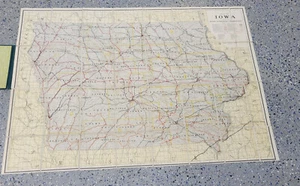
VTG 1900's Rand McNally - RAILROAD - MAP of IOWA- Book w/fabric Fold Out Map
US $95.00
ApproximatelyRM 401.42
or Best Offer
Condition:
Oops! Looks like we're having trouble connecting to our server.
Refresh your browser window to try again.
Shipping:
US $5.00 (approx RM 21.13) USPS Ground Advantage®.
Located in: Crystal Lake, Illinois, United States
Delivery:
Estimated between Mon, 25 Aug and Thu, 28 Aug to 94104
Returns:
No returns accepted.
Coverage:
Read item description or contact seller for details. See all detailsSee all details on coverage
(Not eligible for eBay purchase protection programmes)
Seller assumes all responsibility for this listing.
eBay item number:126086543049
Item specifics
- Date Range
- 1910-1919
- Type
- Railroad Map
- US State
- Iowa, Missouri
- Format
- Folding Map
- Year
- 1900
Item description from the seller
Seller feedback (2,497)
- j***g (4642)- Feedback left by buyer.Past monthVerified purchaseVERY nice item. Fast, and professional shipping. THANKS.
- e***r (214)- Feedback left by buyer.Past monthVerified purchaseFast shipping and product was as advertised.
- s***3 (568)- Feedback left by buyer.Past monthVerified purchaseA+
More to explore :
- Rand McNally & Co. City Map Antique Folding Maps,
- Rand McNally & Co. Antique Railroad Maps,
- Rand McNally & Co. Antique Folding Maps,
- Rand McNally & Co. Lithography Antique Railroad Maps,
- Rand McNally & Co. 1900-1909 Date Range Antique Railroad Maps,
- Rand McNally & Co. Railroad Map Antique North America Atlas Maps,
- Rand McNally & Co. Physical Map Antique Atlas Maps,
- Rand McNally & Co. Antique Physical Maps,
- Rand McNally & Co. 1900-1909 Date Range Antique Physical Maps,
- Rand McNally & Co. 1800-1899 Date Range Antique Railroad Maps