Picture 1 of 12


Gallery
Picture 1 of 12


Have one to sell?
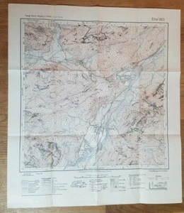
1949 German Bavarian Topographic Map Ettal 863 1:25000
US $9.95
ApproximatelyRM 41.86
Condition:
Oops! Looks like we're having trouble connecting to our server.
Refresh your browser window to try again.
Shipping:
US $8.30 (approx RM 34.92) USPS First Class®.
Located in: Lee's Summit, Missouri, United States
Delivery:
Estimated between Mon, 6 Oct and Thu, 9 Oct to 94104
Returns:
30 days return. Seller pays for return shipping.
Coverage:
Read item description or contact seller for details. See all detailsSee all details on coverage
(Not eligible for eBay purchase protection programmes)
Seller assumes all responsibility for this listing.
eBay item number:115068434334
Item specifics
- Original/Reproduction
- Vintage Original
- Type
- Topographical Map
- Year
- 1949
- Country/Region
- Germany
Item description from the seller
Seller feedback (1,109)
- eBay automated feedback- Feedback left by buyer.Past monthOrder delivered on time with no issues
- eBay automated feedback- Feedback left by buyer.Past monthOrder completed successfully—tracked and on time
- eBay automated feedback- Feedback left by buyer.Past monthOrder completed successfully—tracked and on time
More to explore :
- 1940-1949 Date Range Antique Topographical Maps,
- 1940-1949 Date Range Sheet Map Topographical Map Antique Maps, Atlases & Globes,
- 1940-1949 Date Range Antique Asia Topographical Maps,
- 1940-1949 Date Range Antique Europe Topographical Maps,
- 1940-1949 Date Range Topographical Map Antique North America Sheet Maps,
- Topographical Map Antique Wall Maps,
- Lithography Topographical Map Antique Wall Maps,
- Antique Africa Topographical Maps,
- Topographical Map Antique Europe Atlas Maps,
- Woodcut Topographical Map Antique Atlas Maps